Connect the field with the office and transform operations with centralized GIS mapping, real-time field intelligence, and reliable mobility software. Designed for efficiency, compliance, and profitability.
AbaData is the premier platform for surface land mapping, integrated field operations, and data-driven decision-making tailored for energy companies. By combining powerful GIS capabilities with intuitive mobile tools, AbaData centralizes your operational intelligence—driving productivity, ensuring regulatory compliance, and unlocking profitability across every part of your business.
Unlock powerful visualization and advanced analytics across your entire asset network with Western Canada's most comprehensive surface land mapping platform. Effortlessly integrate GIS data, streamline decision-making, and enhance operational visibility—driving productivity, improving compliance, and accelerating informed responses in real-time.
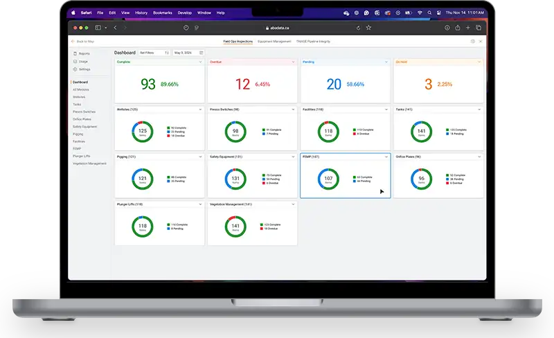
ExploreEmpower field teams with digital inspections, automated workflows, compliance checklists, and instant data synchronization—boosting productivity and accuracy, reducing errors, and enhancing compliance.
ExploreOptimize service routes automatically, reducing travel times, improving response times, and significantly decreasing operational costs through intelligent GIS-based route planning.
Gain instant insights from integrated AI analytics and reporting. Analyze operational data, identify trends, monitor KPIs, and proactively respond to operational challenges, improving decision-making and profitability.
ExploreVisualize your facility layouts, equipment statuses, real-time operational data, compliance inspections, MOCs, and NCR events in interactive schematics. Simplify asset management, enhance operational clarity, and streamline regulatory compliance.
ExploreTrack, manage, and maintain equipment from procurement to retirement. Digitize inspections, preventive maintenance schedules, MOCs, NCRs, and regulatory compliance—improving asset reliability, reducing downtime, and optimizing performance.
ExploreEfficiently capture accurate operational data directly in the field, including production volumes, readings, measurements, and operational events. Automatically validate data at the source, ensuring instant, error-free synchronization with central systems for rapid decision-making and reporting.
Leverage advanced analytics, AI-driven connectivity algorithms, and integrated GIS mapping to proactively identify pipeline risks, ensure regulatory compliance, and streamline maintenance prioritization.
ExploreAccess comprehensive surface land data and powerful mapping to inform decisions instantly and accurately.
Connect and digitize your field teams, automate workflows, and enhance operational visibility.
Pipeline integrity, MOC’s, automated updates, proactive alerts, and streamlined compliance reporting to reduce risk and enhance safety.
Purpose-built AI that helps transform operational data into actionable intelligence. Generate reports, uncover insights, and make smarter decisions with innovations backed by the largest development team in energy tech.
Gain instant insights from accurate field data capture and intelligent analytics—improving responsiveness and efficiency.
“As a large enterprise with complex data needs, we’ve been thrilled with the suite of AbaData software tools. The flexibility and scalability of the platform have allowed us to customize our data solutions to meet our business requirements, and the user-friendly interface has made it easy for our teams to adopt.”
“Our field operations, pipeline and risk management teams appreciate access to corrosion consulting and mitigation guidance within AbaData. They quickly qualify and integrate the work to reduce the potential for leaks at a much lower cost compared with traditional methods.”
“AbaData’s vegetation management module has streamlined our operations and saved us countless hours of work. The mapping and reporting features are incredibly user friendly and have given us greater visibility into our vegetation management efforts.”
“I have been using AbaData’s mapping program for over 10 years. The user interface is intuitive and easy to navigate, and the programs functionality has helped save a significant amount of time on mapping and data analysis tasks.”
Unlock powerful visualization and advanced analytics with Western Canada's most comprehensive surface land mapping platform. Effortlessly integrate GIS data, streamline decision-making, and enhance operational visibility.
ExploreLeverage advanced analytics, AI-driven connectivity algorithms, and integrated GIS mapping to proactively identify pipeline risks, ensure regulatory compliance, and streamline maintenance prioritization.
ExploreEmpower field teams with digital inspections, automated workflows, compliance checklists, and instant data synchronization—boosting productivity and accuracy, reducing errors, and enhancing compliance.
ExploreTrack, manage, and maintain equipment from procurement to retirement. Digitize inspections, preventive maintenance schedules, MOCs, NCRs, and compliance—improving asset reliability and optimizing performance.
ExploreGain instant insights from integrated AI analytics and reporting. Analyze operational data, identify trends, monitor KPIs, and proactively respond to operational challenges, improving decision-making and profitability.
ExploreSchedule your personalized demonstration and discover how AbaData drives operational excellence.